
Highlighting some of My Projects
Through my work with the Rural Electrification Agency and NESP, I have contributed to innovative projects in Earth Observation, Remote Sensing, GIS and Integrated Programming, driving Geospatial solutions, advancing clean energy, and expanding Nigeria’s electrification network. With major contributions on:
- National Initiative for Public Sector Solarization - (2025 – ongoing)
- ECOWAS PRODEL 20,000 - (2024 – 2025)
- Solar Power Naija (SPN) through the National Poverty Reduction with Growth Strategy (NPRGS) - (2023 – 2024)
- Nigeria Energy Support Program (NESP II) - (2022 – 2023)
Earth Observation | Remote Sensing | GIS | Integrated Programming
 QGIS Atlas is a powerful tool for automating the creation of map series by generating multiple maps based on data from a single layout template. Combined with QGIS expressions, it enables dynamic customization of map elements, such as labels, symbology, and annotations, tailored to each feature in the dataset. This automation streamlines repetitive mapping tasks, ensures consistency, and enhances efficiency in producing professional-quality maps, making it ideal for large-scale projects like site selection, land-use planning, and reporting. See the GitHub link |
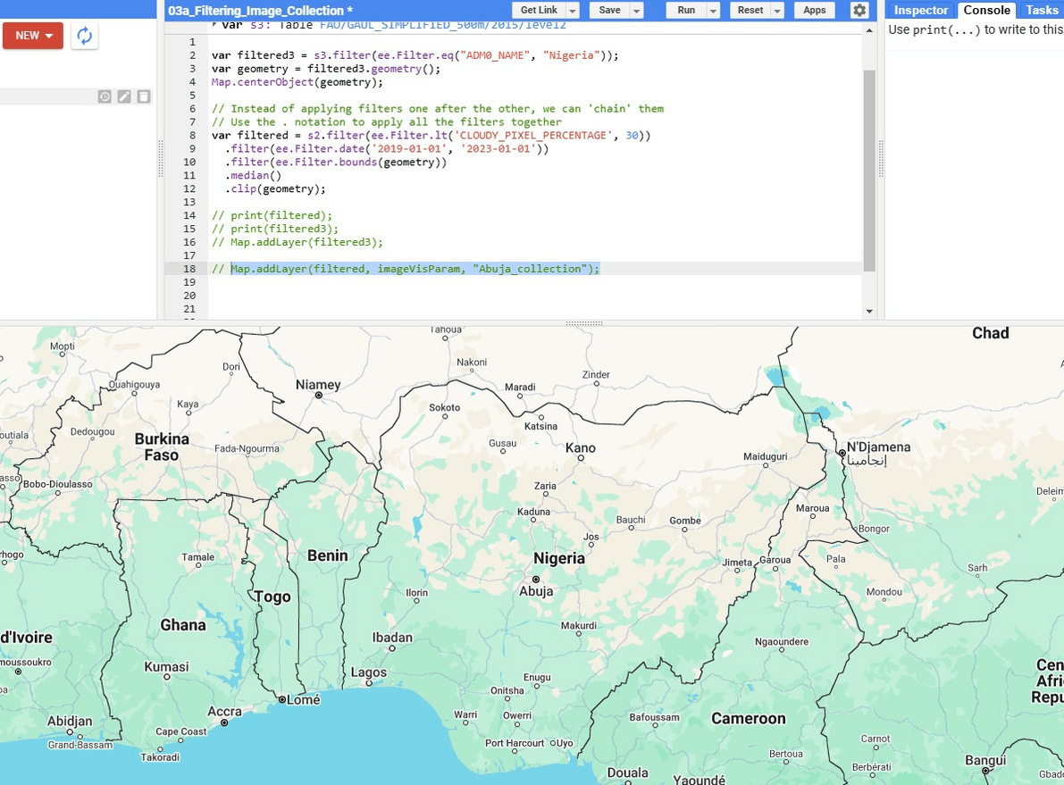 GEE simplifies complex geospatial computations, such as image classification and time-series analysis, making it a vital tool for researchers, policymakers, and GIS professionals addressing global challenges. See the Code link |
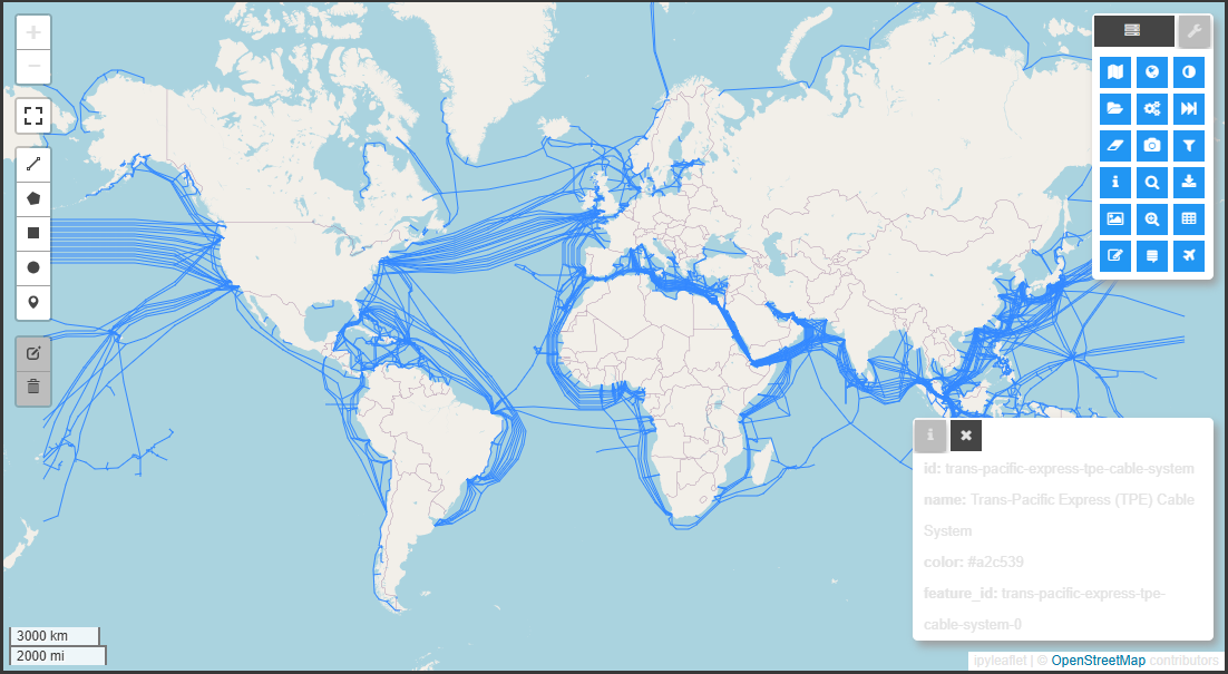
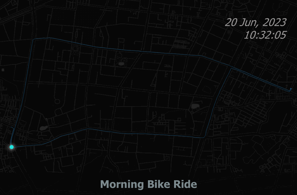 This technique provides a dynamic and intuitive way to interpret geospatial data over time. It involves visualizing temporal and spatial data dynamically, enabling an engaging representation of movement patterns over time. It can be applied in tracking wildlife movement, analyzing vehicle or pedestrian trajectories, visualizing migration patterns or disaster response activities. See the GitHub link |
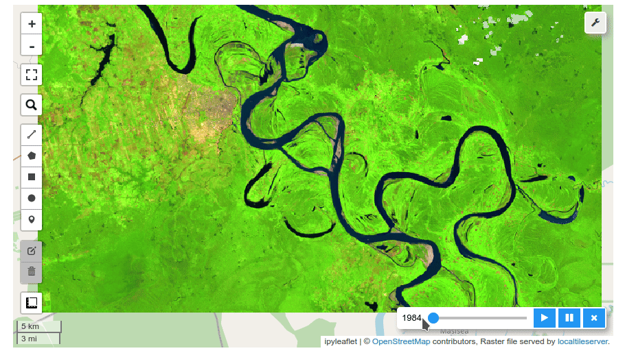 Geemap and Leafmap are Python libraries for geospatial data visualization. Geemap focuses on Google Earth Engine integration for analyzing satellite imagery, while Leafmap specializes in creating interactive maps with tools like Folium and Kepler.gl. Both simplify geospatial analysis and visualization. See the Code link |
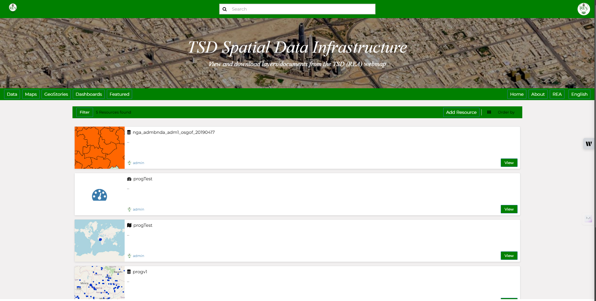 Spatial Data Infrastructure (SDI) involves creating a framework for managing, sharing, and accessing geospatial data efficiently. GeoNode/GeoServer for geospatial data management, Docker for efficient deployment, and GeoDjango for custom spatial applications. See the GitHub link |
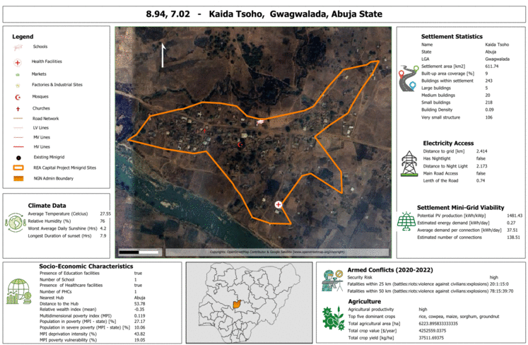
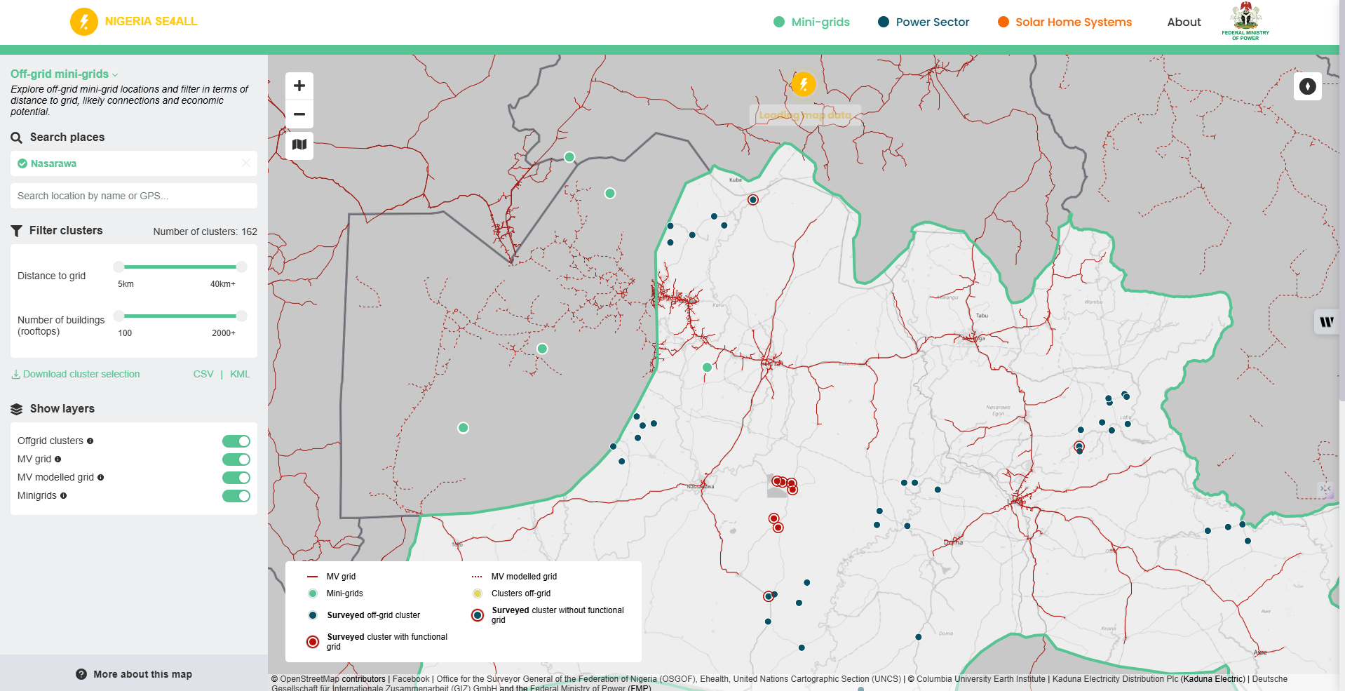
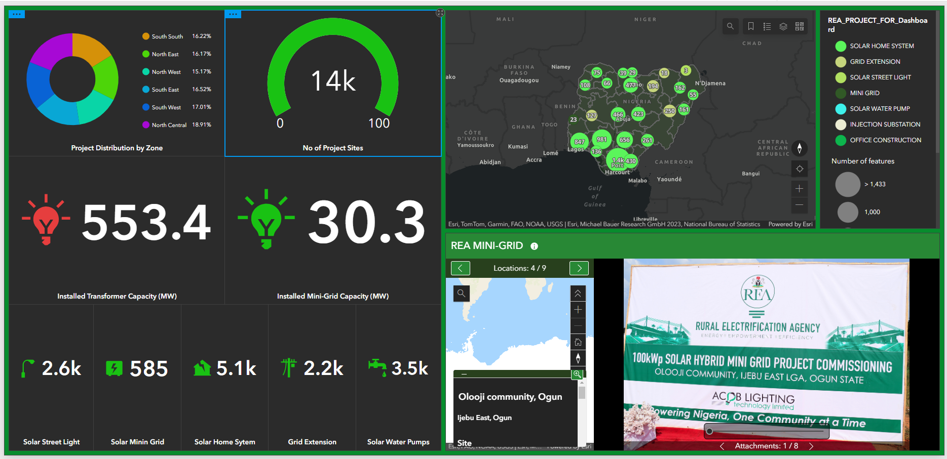 These visualizations provide insights into energy project distributions, grid extension coverage, and areas requiring intervention. Custom symbology, labeling, and spatial analytics allow stakeholders to identify patterns and prioritize efforts effectively, ensuring that unserved and underserved communities benefit from targeted energy access initiatives. See the GitHub link |
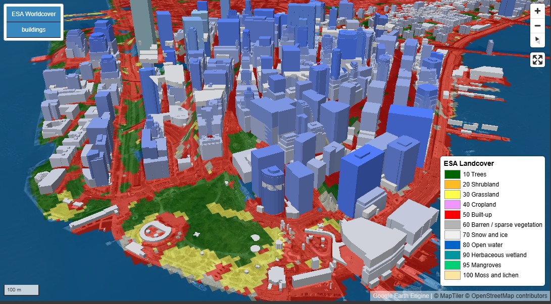 Spatial Data Analysis combines data engineering and visualization to transform raw geospatial data into actionable insights. It uses techniques like geocoding and spatial clustering for analysis, while tools like heatmaps and 3D mapping make complex patterns clear, enabling informed decisions for challenges like urban planning and renewable energy deployment. See the GitHub link |
 This exercise focused on creating a geospatial analysis and visualization workflow using Python's GeoPandas and Leafmap libraries. The goal was to enhance my proficiency in handling geospatial data and developing interactive maps for spatial data analysis. The excercise strengthened my ability to manage geospatial datasets, develop interactive visualizations, and integrate open-source Python tools into GIS workflows, laying the groundwork for future geospatial analysis initiatives. See the Code link |
 My involvement at INTEGRATION Consulting as a Geodata Analyst, enabled me to contribute this project under the Nigeria Energy Support Program (co-funded by the EU and German BMZ, implemented by GIZ). In this role, I was established as the primary point of contact between REA and INTEGRATION Consulting, as regards geo-data collection, survey development, remote evaluation, as well as coordination and alignment of capacity-building efforts, ultimately enhancing GIS capabilities within REA and other relevant stakeholders. |
 Since joining the REA as a Technical Assistant to the office of Executive Director on Geospatial Analysis, My work has enbled the Agency to successfully implement 160+ MW of clean energy, extending the national grid by over 5,00km. See My Last 6 Months Appraisal duly assessed and signed by the Executive Director |
My Tech Stack
Python
In my role, my Python tech stack includes GeoPandas, Shapely, Rasterio, and GDAL for spatial data processing, along with Scikit-Learn and TensorFlow for predictive analytics. Tools like VS Code (Interactive Window), Jupyter Notebook and Anaconda aid in experimentation, while SQLAlchemy manages spatial databases. With Matplotlib and Folium for visualizations, I deliver clear, actionable insights for the energy sector and beyond.
- I can help you get started with Python, check My Python Learning Journey
JavaScript
As for JavaScript, I focuse on web-based geospatial visualization and data interaction; Leaflet and Mapbox GL for interactive mapping, D3.js for complex data visualizations, and Turf.js for spatial analysis directly in the browser. For front-end frameworks, React pairs well with these libraries to create dynamic, user-friendly interfaces for data insights. Additionally, Node.js supports backend processing for data handling and API integration, while libraries like Axios streamline data fetching. This tech stack enables me to deliver accessible, interactive geospatial solutions that communicate complex spatial data and tools effectively for relevant stakeholders.
- To get started with JavaScript, check My JavaScript Learning Journey
AI Career Essentials >
AI-driven approach streamlines processes, improves operational efficiency, and ensures optimized workplace performance through actionable intelligence. other than leveraging Python libraries for automations and building machine learning models, tools like NLP models (using libraries like spaCy or Hugging Face) help automate text-based data analysis for report generation and communication.
- The ALX Africa’s AI Career Essential course will provide you the needed headstart. You can also check my personalized AI toolkit.